Stage 10 National Forest Way: Branston Water Park & Rangemore
The National Forest Way takes walkers on a 75-mile journey through a transforming landscape.
This 4-mile stage of the Way takes in the plateau of Needwood Forest and the floodplains of the Trent Valley.
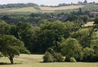
Along the way, you'll take in the spectacular panorama of the National Forest from Battlestead Hill, which lies on the eastern edge of the plateau and the pretty village of Tatenhill, which nestles behind it. You will walk alongside the historic Trent & Mersey Canal and visit Branston Water Park, a nature reserve created from a former gravel quarry.
Location Map
Burton upon Trent Staffordshire
Points of Interest
Branston Water Park
These restored gravel pits feature one of the largest areas of reedbed in Staffordshire, together with wet woodland, open grassland and wildflower meadows. These valuable habitats attract a wide range of birds, butterflies and other insects.
Tatenhill Lock
Tatenhill Lock is one of 76 locks on the 93 mile Trent and Mersey Canal, designed by James Brindley and completed in 1777. Today the canal is an attractive and tranquil spot where wildlife and people coexist happily.
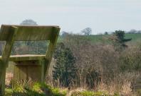
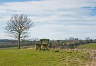
Battlestead Hill
Battlestead Hill is reputed to be the site of a bloody battle between the Angles and Danes. This mature woodland is attractive in all seasons and especially so in spring, when primroses, bluebells and violets carpet the forest floor.
Rangemore
Rangemore is located within the ancient Needwood Forest. Rangemore Hall on the outskirts of the village has historical connections to Burton upon Trent's famous Bass brewing dynasty and has welcomed royal visitors. Today the Hall has been converted into private residential apartments.
Image Gallery