Stage 7 National Forest Way: Hartshorne & Moira
The National Forest Way takes walkers on a 75-mile journey through a transforming landscape.
Between Conkers Waterside and the village of Hartshorne, this 6¼-mile stage of the Way takes you through pastoral countryside cheek by jowl with the scars left by two centuries of coal and clay extraction. Here you will see the greatest transformation in The National Forest: tree planting has truly turned the land from black to green.
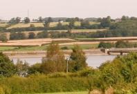
The hills above Hartshorne offer a fantastic panorama of how the creation of new woodlands is changing the landscape of the National Forest.
Location Map
Moira Derbyshire
Points of Interest
Conkers
Conkers is at the heart of The National Forest. Built on a former deep mine, it was one of the first visitor attractions to be developed. Here you can explore 120 acres of forest, adventure play and over 100 indoor interactive exhibits.
Feanedock Wood
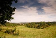
From the top of Feanedock Wood you will be rewarded with a panoramic view over the transforming Forest landscape. The active landfill site will in time be restored to create new wildlife habitats and open access woodlands. The view on the other side opens to the attractive rolling hills of the Ashby Woulds.
Blackfordby Spring
At the bottom of the hill in the village of Blackfordby look out for a natural spring dating back to the 11th century. Legend has it that the water has never frozen over.
Hartshorne
Hartshorne village is set amongst pleasant hilly farmland. The Church of St Peters contains the family tomb of the Dethick family, one of whom went to Cleves to find a fourth wife for Henry VIII.
Image Gallery